Seventh in a Series
Welcome to another episode of “Forest Mystery Theatre,” I’ll be your host this evening. Tonight we turn our attention to a mystery presented by Nico. And since I’m always up for an armchair challenge …
If you know this one, odds are you know it as Jackson Cabin. I know, I know, right there I’ve blown all the suspense and dropped it up front … but there’s a story to learning the story, and having been recently labeled a “raconteur” by an expatriate, I now feel compelled (obligated) to share at least part of the legwork in unraveling the legend.
Jackson Cabin Tour, courtesy Ventura County Canyoneering
Many believe Jackson Cabin to be a rancher’s cabin. That’s somewhat the case now, as it’s owned by the ranching family who lease the land on which the cabin now sits. But that wasn’t always the case. A few of us had heard tell it was once situated “somewhere higher,” and moved to its present location. That always seemed a bit implausible to me; I thought perhaps it was an old AWS building left to languish on these sun-baked hills, doomed to a life of hikers’ vandalism and bovine indifference. And so whilst I cobbled together other “Lookout!” entries in my focus districts (Ojai, Mt Piños, and Santa Barbara), that little dilapidated wooden building along the Jackson Trail just over the Santa Lucia line never became a focus until the night (morning) it all (mostly) came together.
For months (okay, longer) I hadn’t realized I’d already read really everything I needed to know to piece this little riddle together. My bad. I simply didn’t realize the pieces — taken individually — were parts of this puzzle (there’s some metaphor about the “forest for the trees” here, but in this case that almost seems too punny). So as is often the case, it wasn’t until another whisky-fueled night of research and writing in the dungeons of maptitude that I had three of the final four pieces in my view at the same moment.
First was a photo in the Beeman’s picasaweb stream; just browsing his photos and reminiscing about my and ZK’s own trip to the Sierra Madre Ridge the month prior (detailed here, here, and here).

Second was a photo of the old Miranda Pine AWS cabin in Burtness’s 1963 guide. Both Jackson Cabin and Miranda Pine were clearly of the same design and same era (flip Beeman’s image and overlay them and — forest-forensically speaking — it’s a match) … but I knew the Miranda Pine cabin had been destroyed, not relocated.

Surely if Jackson Cabin was transported, it couldn’t have come from too far away. Miranda Pine was gone, and what’s to say it was moved after the two sections of 32S13 were finally connected? Even if it was post-connection, it seemed unlikely it came from too far west. McPherson Peak? Type C on-the-ground lookout, unlikely it would have needed the separate cabin … and it stood until well into the 80s. Cuyama Peak? Nope, still standing … with (barely) its own AWS cabin to boot.
Couldn’t have come from further east than the Cuyama, I reasoned, at least not back in those days. That would have been a pretty massive undertaking on skids and a dirt road. Wait a sec … what about Salisbury Potrero? That seemed almost too easy, yet I knew nothing and had read nothing of that lookout’s fate. So then of course came the first test run by any man who locks himself in the dark with a collection of single malts and old maps: I went to the shelf and dusted off the 1950 Los Padres (East) visitor map.
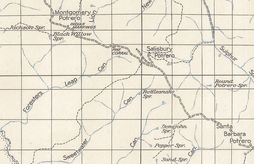
And there — quite plainly — was the service road and a building shown above Salisbury Potrero, due east of Pine Corral. Just as important, there was no building shown at Black Willow Spring (which later LPNF maps do show).
And then third — almost to rub salt into the “I can’t not know” wound — was a reference in Blakley’s 1984 historical overview of the Los Padres NF, wherein he mentioned that only two AWS cabins of a certain design were (as of his writing) still standing on the forest. One on private lands in the Monterey RD, and one at Black Willow Spring in the Santa Lucia. That’s our cabin. Just having it reinforced that it was definitely an AWS building lit the proverbial fire under my research glutes, and so I took the next logical step: find somebody who knew the history (duh).
I started with the rangers in the Santa Lucia and Mt Piños RDs (the latter having absorbed the old Cuyama Ranger District in 1972). Some good leads, but not the entire story. Next step, I got in touch with Bob Burtness, legendary Santa Barbara-area (and still active) Scouter (and contemporary of Blakley) who’d written several of the classic camp guides for the Mission Council and has been a great help in my research for the upcoming guide. He knew a few things, and brought some other folks into the conversation who knew more. Finally, I got in touch with the owner of the cabin.
My eloquent and lovely prose query received the following prompt response:
“On the ridge above Salisbury Potrero. It was an air craft warning station.”
I think that’s classic minimalist Cuyama cattle rancher style, but I can’t be sure. Short and sweet, but all I needed. Mystery solved.
Tune in next time, when we unravel the mystery of < insert some clever 40s-era radio static in your mind here > …
Leave a Reply