A few years ago, Billy Monster and I spent a few days tramping the Great Barrier Forest in New Zealand. Upon my return I drafted an article on speculation and pitched it to numerous outdoor magazines (meeting rejection at every turn … the life of a writer, n’est-ce pas?).
Finally, I pitched the piece to a New Zealand magazine, and lo and behold — they went for it. What was ultimately released was a very stripped-down version more in line with that magazine’s style (see “Whangaparapara Day Walks” over in the library for that edition). No complaints there — Wilderness New Zealand has been good to me and I’ve really enjoyed doing the occasional piece for them.
But now, armed with this site, I’ve got a venue with which I can subject unsuspecting readers to the original version. 😉
Enjoy.
Great Barrier Island
by Craig R. Carey
I’d spent hours poring over maps of New Zealand looking for a few day trips on the proverbial track less travelled. Kiwi friends and guide books ticked off all the usual spots, and it seemed the South Island was the sure bet until I spotted Great Barrier Island.
I asked a friend living on the Coromandel if he’d ever been, and he just laughed. “I don’t know anybody who’s been there, mate.”
Excellent, I thought to myself. That’s the spot.
So under threatening morning skies, we arrived at Whitianga Aerodrome on the North Island’s Coromandel Peninsula about half an hour before our scheduled departure. Between light showers, the pilot called in on the two-way to let us know he was making a drop-off in Tauranga and would be along shortly. My brother Bill and I each fixed ourselves a cup of tea and watched Cook’s petrels (Pterodroma cookii) wheel in the gusts over the grass field that comprised the runway. In these parts, this spot was the major airport and our weathered wooden bench the café.
The Piper Cherokee 6-seater arrived shortly, and we — along with a beekeeper who kept hives on Great Barrier Island and a fisherman out for snapper — waited while the pilot refueled. We soon taxied onto the grass runway and throttled north. The view from above the peninsula was spectacular; flying over Cape Colville and Colville Channel one is granted a view of pristine land and sea far removed from the rest of the world. The irony that we were further removing ourselves to near-no-man’s land was not lost on any of us aboard the 30-year prop plane.
Great Barrier Island, New Zealand’s fourth-largest, is situated some 90 kilometers (55 miles) northeast of Auckland. Long a site of Maori settlement, Aotea — “white cloud” in the Maori tongue — was assigned its English moniker by Captain James Cook, who upon sighting the isle and its lesser companion (Little Barrier Island, or Hautura) noted the calming effect both islands had on the surrounding waters of the Hauraki Gulf.
The island has only five villages, and the entire population is a sparse 1,000. This is a well-preserved and largely uninhabited place; 285 square kilometers of subtropical rain forest dominated by kauri, broadleaf and kanuka — a lush and almost primeval land spared the ravages of the deer and possums that have been introduced to the other major islands of New Zealand. Much of the island (nearly 70%) is administered by the Department of Conversation (DOC).
We landed at the Claris Airfield, another strip of grassed earth tucked between a stretch of marshland and the outer waters of the South Pacific. There we were greeted by Barry Rowe, who along with his wife Dale is one of the “off-season” caretakers at the Great Barrier Lodge in Whangaparapara. (The west coast hamlets of Port Fitzroy and Whangaparapara are generally considered the best points from which to access the Great Barrier Forest; it was from the latter Bill and I had opted to base our sojourns into the fabled bush.)
We piled into Barry’s Mitsubishi wagon and as we rattled westward along the alternately sealed and washboard gravel road, we were indoctrinated with a brief but matter-of-fact history of the island and its denizens and cautioned against the flashfloods that make the road impassable during periods of heavy rain.
The narrow strip of sealed road that winds below the lodge’s grounds is ringed on the waterside by massive pohutukawa trees (Metrosideros excelsa). Valued for their hard timber and used by pioneering sailors to fashion ship members, these evergreen trees of the myrtle family have a penchant for growing along beaches (“pohutukawa” is Maori for “sea-sprayed”) and are famous for the starburst-shaped crimson blossoms that bloom at the height of New Zealand’s summer (Christmastime). Wider than they are tall, the trees live to be several hundreds of years old, and these gnarled sentinels standing guard along Whangaparapara Road also serve as aeries for the local avian population.
Barry, our erstwhile tour guide, also serves as the local “dog ranger” and after our arrival was quickly en route to an incident involving a loose dog. (Dogs are neither as ubiquitous nor universally well-received in New Zealand as they are in the States, at least on the North Island and its immediate environs, given the damage they render upon the ecology. While valued as pets, their containment is taken seriously here.)
Bill and I quickly dropped the bulk of our gear in the tidy studio unit, stuffed the requisite items for a few hours’ tramping into our technical bags, and headed out to scout the bustling metropolis (population: 45) of Whangaparapara and its surroundings. The entire island is technically part of the Auckland City territorial authority, but on the lonely, windswept jetty of Whangaparapara Harbour, Auckland seemed a million miles away and the modern NZ Telecom payphone seemed out of place, particularly with the long-abandoned whaling boat beached in plain view across the harbor.
“Hello the pier!” a man hollered from a beautiful (Swiss-designed, we later learn) catamaran. We waved to him and his wife, and made our way back along the road and through a DOC gate perhaps half a kilometer from the jetty.
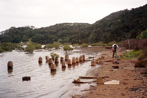
Upon crossing Whangaparapara Stream and the mangrove-strewn waters wherein the harbor and stream meet, we followed Old Mill Track, eventually coming upon the remnants of old wharves and cast iron boilers used during the peak of the kauri timber industry. Kauri, of all the timber in New Zealand, was and is the most prized. Now protected, their harvest was a huge business and Great Barrier Island was the scene of heavy logging, particularly from the 1920s to early 1940s.
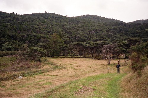
We returned along the same path from the mill site to the stream and were soon greeted by a solitary cow who’d taken little interest in our initial arrival. After a cursory investigation, she left us to our tramping. Our destination was Mt. Whangaparapara, the most prominent feature to our north at an elevation of 309 meters. Like the pohutukawa lined along the shore now far below us, the track was enclosed on both sides by kauri of various girth and age, fern trees, nikau palms and thick duff rooted in places by wild boar. Winds and light showers buffeted our ascent, which provided us spectacular views of Mt. Maungapiko and Mt. Young to the north and ultimately of the Broken Islands to our west. For as well-maintained as the tracks in the Great Barrier Forest were, it was plain to us we were the first to tread here in some time.
A quick descent back to the harbor saw us again greeted by the single cow. Now, however, she seemed truly interested in our progress on foot. By the time we reached the gate she was no more than ten feet away; we were quick to hop the fence rather than open the gate, wary this stalking bovine might suddenly yield to some Pamplona-esque urge and rush us.
Dinner that night was had in The Whale Boat, part of the original mill manager’s house overlooking the harbor and now the lodge’s restaurant. Bill and I (instantly referred to as “the boys”) were joined by an American woman visiting New Zealand solo and a Whangarei couple who’d moored in the harbor and had opted for a meal ashore rather than in the galley. Dale, who had sworn several times over she was no master chef, nonetheless produced fantastic fare of chicken, kumara (sweet potato), and greens.
We discussed over dinner each party’s plans for the next day; our compatriot planned to read and simply relax much of the day — and this was certainly the place to do it — and our sailing friends would continue their voyage. Though a fairly heavy storm was forecast, Bill and I decided on a tramp back into the wilderness to investigate the highly-regarded Kaitoke hot springs and one of the old tramway tracks left from the kauri logging days.
Stateside, my interest in rugby has few outlets. Yet while traveling I’ve found being a fan can make for an excellent icebreaker. This has especially proven true throughout my travels down under, as it’s been said on more than one occasion that rugby is the true religion in New Zealand. When talk amongst the Kiwis at the table turned to the 2005 British and Irish Lions tour that was underway, I kept in the conversation by offering my opinion of the players’ recent performances and injury concerns and my take on the coach’s decisions. This topic and a dozen others carried us far into the night, tucked away in our little corner of this remote island.
The island is in fact remote enough one will find neither bank nor public transport on Aotea; the place is so self-contained I found myself surprised to see that payphone at the harbor each time I spotted it. The island also has no central electricity; electrical needs are typically provided by petrol or diesel generators and banks of 24-volt batteries, supplemented by solar panels and wind turbines. Credit cards are accepted at some stores and a few restaurants, but EFTPOS (debit) is more commonly accommodated. Be warned overseas cards’ coding (even those with debit function) is often incompatible with EFTPOS machines and rendered useless. Needless to say, cash works best.
Around 3:00am on our second night in Whangaparapara, the heavens opened. For the first week of our time in New Zealand (the Northland and the Bay of Islands), we’d been blessed with near-perfect weather, and there had only been one day with any measurable rain. Not so this morning.
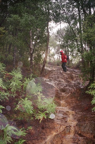
We arose roughly around the time we reasoned the sun would have come up over Te Ahumata (“White Cliffs”) due east of us. Bill and I ate breakfast in the lodge slower than usual, chatting with the local fisherman (in for supplies and who upon hearing our American accents quickly commented on Zane Grey’s love for fishing these waters) and waiting to see if the storm would break before our departure into the bush. Our hosts were fairly certain we’d opt for a day indoors given the inclement conditions outside, but we assured them we were still planning to trek back in for a second day of tramping through the Great Barrier Forest. In response to our temerity, the rain continued through breakfast and only intensified while we got geared. We left along the sealed road that quickly becomes a rutted gravel strip in a downpour that had already lasted nearly five hours.
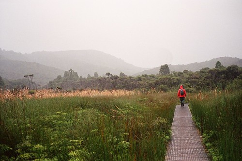
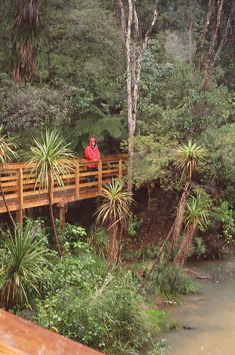
Where the Kaitoke Hot Springs track cuts from the main road some three kilometers from the lodge, we tramped north and again marveled at the engineering and fine maintenance of the DOC track. Solid wooden bridges spanned the creeks, erosion control was well-planned with troughs alongside the track, and a long stretch of raised wooden platforms led us over an expanse of the Kaitoke Swamp.
With no break in the rain, we traversed the higher portions of the trail toward the Kaitoke hot springs, evidence of the island’s active geologic and volcanic history. A check of our bearings and the map safely stored in a Ziploc confirmed we were approaching the springs. But the trails, now inundated despite the well-engineered erosion measures, were flowing with enough volume to appear streams themselves. We tramped alongside two tributaries and found several pools that had obviously been dammed by previous visitors, but found the water only lukewarm at best. The rain had, in the most literal sense, diluted our plans.
We ascended a brief knoll and then made our way down an extremely steep and extremely flooded slope toward the junction of the old logging tramway track. Welcoming the rain’s company, we made a circuitous trek back toward Whangaparapara Harbour.
The night of the storm, the Lions’ rugby match against the Otago provincial team stopped all other business. I sat with Dale over a few bottles of Speight’s Old Dark and watched the valiant southern men of Kiwi rugby succumb to the crème of the British Isles’ rugby unions 19–30. (The Lions would not fair so well against the vaunted All Blacks, New Zealand’s national team, over the course of the Series.)
The next morning the sun broke over Te Ahumata bright and clear. The harbor was still and perfect as though forged of dark blue glass, a marked contrast to the dark, swirling waters of the previous day. I was loathe to depart such a glorious place.
By mid-morning, after an early hike along Blackwell Road out toward Oruawharo Bay and back, we found ourselves nestled again between the swamp and the South Pacific, sitting along the grass of Claris Airfield awaiting our trip back to the North Island. There again we met with the beekeeper from our flight in — Andy Williams, who runs 309 Honey back in Whitianga — and a pilot of one of the local fishing vessels who also worked as a postmistress and was heading to Whangamata further south.
As inclement weather back on the “mainland” delayed our incoming plane, Andy (as Barry had done days earlier) provided his new American mates a thoroughly friendly crash course, this time in Kiwi apiculture, bringing us and the pilot up to speed on the threat of Varroa mites, the option of European hybrids and what they might mean for the New Zealand honey economy, and the subtle differences between manuka (the Northland term for kanuka), pohutukawa and clover honey (Andy and his wife Susan specialize in organic manuka). We passed my bag of trail mix around while the pilot then discussed the regulations of commercial fishing in New Zealand, limits for personal use, and the market for and migrations of various species.
The moments in which none of the four spoke were punctuated by a noticeable but comfortable silence; with the exception of the occasional gust of wind in the swamp and bush and the distant sound of waves pounding Kaitoke Beach, all was quiet. So when the prop-job came in from the south around two that afternoon, we’d heard it from far away.
That gave us time enough to accept the fact we had a plane to catch.
Leave a Reply